9/5/12 Monday.
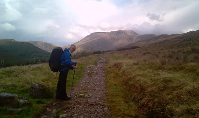
Monday dawned after a night on the flood plain at the back of the Kings House at the top of Glencoe. We hit the road (the old military road that is) at 7.45. It started to rain at about that time and continued on and off all day. In the intervals of rays of sun the visability was great with some superb lighting effects. Especially the view of the Ben from the Larig Mor (Big Glen up which the Campells retreated pursued by the McDonalds after some battle a bit above the usual cattle raid). We saw several herons as well as grouse and ptarmigan and an as yet unidentified warbler. We left our options for the day open but the repetitive nature of the rain an the persistance of the current frontal system forcast until Thursday or Friday convinced us as to our best course.
We walked from the top of Glencoe to Glen Nevis camsite 2miles out of Ft William in slightly over 8hrs with an brunch in Kinlocleven, about 21miles in not great conditions but showing the excellent line (if not the current quality) of the WHW route on the 17th century road built to subdue the highlanders.
We arrived and checked in to the Glen Nevis campsite. One deficit of this otherwise imaculately groomed site is there is nowhere for those camping to cook, indeed teutonic style signs specificaly forbid it in every possible location.
Tomorrow we will catch the train back to Glasgow having promised our feet a chance to recover from incipient trench foot.
Link to where we are on Google Maps
7/5/11 Saturday.
The rain overnight was fairly heavy at times leaving wet tents to pack up. Our Golite Pinacle sacs have useful straps on each side, ideal for strapping wet gear on to. Rain continues intermittently and we have the usual game of on and off with wwaterproofs until the sun peers though the mists. We had hoped to climb Ben Lui on the way to Tyndrum today but the rain, mist and forecasts of 60mph gusts of wind on the tops rather turned us against the idea. So the low route it was, following the WHW as written with both guide books exaggerating the 19 miles to travel, only at our peak of fitness in Spain would we cover this distance in 5 hours and then with light packs, we think it is being talked up.
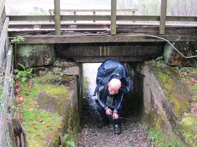
The main road and the railway line are crossed several times by the WHW, the first under line is a cunningly shaped cut through that gets lower as you pass through necessitating a hands and knees exit for those burdened with sizable packs.
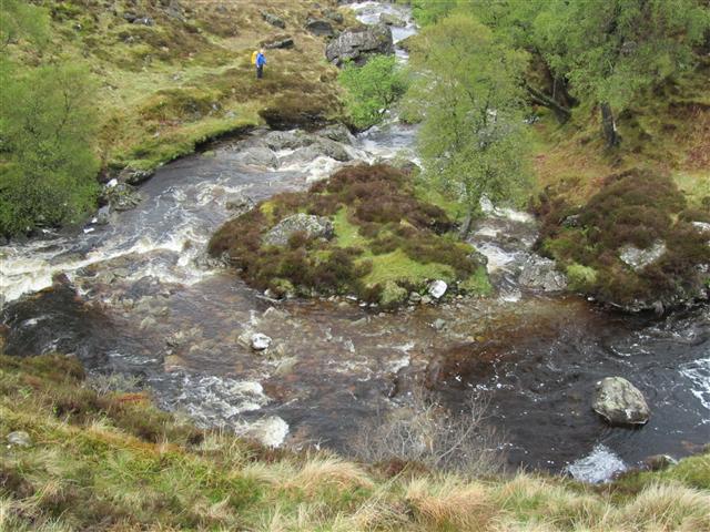
The day improves and we dry out slowly, but the tops are in cloud and we see the sun occasionally. We have coffee at a farm shop midday by St Fillans's priory, now ruined and pass through the Millenium forest., this is the local attempt to reintroduce the Caledonian forest. Finally, via a still bare area where lead ore from a mine in the hills was separated, poisoning the ground, we arrive in Tyndrum at The Green Wellie Stop. That well known tourist mecca is humming with activity. A gold mine has replaced the lead industry in recent years.
We have a couple of hours drying out time then the next front reaches us and this post sent from our tents with rain pattering on the outsides.
Link to where we are on Google Maps
6/5/11 Friday.
Today we had determined to follow the WHW sort of over the hills east of the northern part of Loch Lomond rather than the tame lochside route.
The very nice bunk house had a drying room of great eficacy and by morning all clothes and boots were dry. Alas not for long. We headed up the road to the farm at the ruined garison (built to contain and capture Rob Roy, he and his son burnt it to the ground). Turning up the hill to follow a fence boundary we had a short discussion with a herd of Highland Cattle and headed up into the mist and light rain. Quite quickly we realized we had been seduced by a younger and more prominent fence and had to back track to find the elderly rusted fence we were to follow through the rain for the next 10km.
The fence itself is remarkable with iron posts and rusting wire still more is its route up near vertical rock and through bog and lochan. Our problem was to follow it as closely as possible and in poor visability this was not easy, at one point becoming seperated we experienced a worrying 10mins before finding each other further down the line. The terrain was such that loosing the fence and without a GPS there would be doubt as to ever finding it again. Still all good things must end and as we started to descend from the last minor summit down more bog and peat hags the sun briefly shone, from that point the day looked up and we even started to dry out a bit as we descended off Cruach at the side of Ben Glas Burn seeing some beautiful waterfalls on the way down to Loch Lomond. We are now camped at the north end of Loch at Beinglas campsite washed and drying in the evening sun after a day both of us would rather forget.
Link to where we are on Google Maps
5/4/11 Thursday
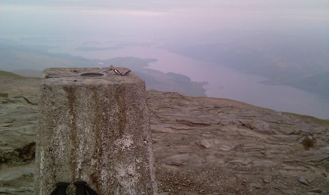
Last night we camped a few hundred feet up the tourist path up Ben Lomond and this morning took down the tents just as the rain started at 0645 a damp day ensued with views of the largest body of fresh water in the UK (they seem to like their records round here!) severely curtailed. Ben Lomond is a bit like Snowdon via the PYG track but off piste to the north is fairly trackless until over Cruinn a Bhein (a Corbett). The mists did clear enough for a view of Lock Lomond to the south and we were puzzled by the two padlock attached to the trig point, maybe it would otherwise escape. We were back down to loch level by 1200 with a Munroe and a Corbett in the bag, but a wet walk up to the next stop of about three rmiles was needed to complrte the day. After a "swift arf" we climb the back road to a very nice bunkhouse (converted old church with original stained glass) well it is still raining we are wet and the tents are not, with two more days of rain forecast it seems a good idea to dry out.
It is a bit of the UN along the route, probably as many from out of UK as from within. Organised transfers are used by many and many seem to think 7-8days adequate time. We suppose with no kit and up the main route with no deviations that's about right. Tomorrow we are off into the hills again but it may not be much harder than the lochside which is said to be a fairly rough path up this section.
Link to where we are on Google Maps
4/5/11 Weds.
We get up before the chickens having slept well after our meal in the"oldest" pub in Scotland. Unfortunately we missed the man to pay for our nights stay.
Heading north past Drymen we climb up through the forest and past the wild campsite (surely an oxymoron ) and up Conic Hill a Marilyn of distiction (a Marilyn is a hill sticking up more than 150m above the surrounding country) . Excellent views over Loch Lomond and including our Monroe for tomorrow Ben Lomond were seen in perfect conditions.
Descending down to Balmaha we bought three days worth of breakfasts to facilitate wild camping up the east side of Loch Lomond and then continued up the lochside to the Rowardennan Hotel to eat and then climb up the first 200m of Ben Lomond. The weather while perfect at present is set to deteriorate tomorrow so an early start should allow us to beat the front and be back at lochside for the next night.
Link to where we are on Google Maps
Final day of the Ramshackle Rally.
Out early for the drive to Zakopane.
there for lunch and to get Keith a ride on a cable car.
At that point the rain started which followed us down the hill into Krakow.
Our final meeting place is in the castle where we must present our beermat collection (don't ask, just another silly challenge) and discover how many of the original 35 teams have got here, with or without their car.
And later tonight after a little liquid refreshment, the prize giving!
Photo is of a typical Polish rural house.
Link to where we are on Google Maps
Another long day today. 400+ miles, plus lots of ascent, in a Volvo which cost £150.
We went over the Brenner pass into Italy and then east to get the road to the Großglockner. We got to the glacier (which looks a lot smaller than when td was last here in 1970), and then on to find some snow for a snowball fight.
Finally in Bratislava we had to identify some statues from around the city which was terribly easy as the hotel receptionist told is where they were.
Roll on Poland!
Today we stayed clear of toll charging autorou
tes and went cross country from Strasbourg to Innsbruck rather than the conventional route.
this allowed for lunch on the banks of Lake Constance (Bodensee) and a climb over the Alps into Austria.
en route we managed to give away some pigs to confused German children. Look at the face of a recipient of a pig knitted by Jane.
Yesterday we gave away a pig to a policeman in a patrol car complete with prisoner.