To Lisle

30.06.08 Monday.

Brantome to Lisle.

Got up and packed up as our two families of mallard ducklings came to see us off. They still looked stuffed with bread from yesterday evening so got no more. Early start into Brantome for 0070 and breakfast. Then off up a steepish slope on to limestone uplands and then down past a well restored mill properly using the water to turn unlike one in Brantome that we strongly suspect of being electrically driven!
A text from Rhona (Tim’s daughter) saying she had stopped with friends on the way to a wedding yesterday to try to help a dead motor cyclist and was coming to terms with the experience, lead to a necessary phone call from the top of a hill and an email later. I marvel again at the telecommunications we are using and the complete isolation that our medieval pilgrims would have had from friends and family.
The day rapidly warmed up and we entered Lisle at 1200 after 5 hours and 12 miles with a sense of great relief for lunch at the local pizza place. The village may only have 900 inhabitants, but they manage to have 4 bars along with various other shops. How do they all keep going?
A hot afternoon was spent showering* and washing socks etc in the usual way. After we had all showered and were lounging around on the great little Municipal site once again the only occupants, Geoff started hunting for a sock he had washed, Tony who showered last reported that the showers were not draining water down their plugholes and it did not take genius to realise where Geoff’s sock had ended up. A piece of stiff wire from a broken trellis allowed probing of the system and the release of a quite disgusting sock from its incarceration. This was accompanied by loud gurgling noises and the disappearance of the water, to our great relief as we did not fancy explaining the situation to the campsite guardian when they arrived.
GF adds; only following Tim’s advice* to put the clothing in the shower, add soap and tread on it while cleaning oneself. Stupid to have such a large plughole!

Link to where we are on Google Maps

Rest day in Brantome

29.06.08 Sunday

Brantome. Rest day.

Contact with Geoff who has arrived in Bordeaux, he will try to catch a train to Perigueux and meet us in town this afternoon/evening. A walk to the supermarche Shopi, just out of town, for food for today and tomorrow: we were asked if we had a loyalty card, very nearly tried to get one as we have used these little small town supermarkets all the way down France, they seem about the same size and frequency as Spar back home. We also have bought a paper map with the next bit of GR network on it and together with the map of several useful campsites (that the man in the tourist office swears were current only last year) we are plotting the route for the next 2 weeks. At the end of this we don’t yet know were we will be but Geoff, your challenge, should you care to accept it, will be to get back to Bordeaux in time for your flight home.
Met Geoff on the bridge in front of the Abbey at Brantome so he really is here, had a couple of beers to celebrate and went back to the campsite, full 4 course meal with wine, still don’t think he knows what he’s let himself in for. About 12 miles tomorrow, breaking our new recruit in gently, though it will probably be hot.
Plenty of wildlife on the campsite with return visits from our friendly duck families and the occasional sighting of a very lively young rat..
GF adds it’s all correct. Taxi fare here cost me more than the flight from B’ham though so needed to go straight to the hole in the (wailing) wall and pray the electrons would work for me – they did. Setting up camp now few yards from the others- someone will snore tonight and disown it. To be fair, the four course meal included a litre of wine per man.

Link to where we are on Google Maps

To Brantome

28.06.08 Saturday.

Chateau le Verdoyer near St Saud Lacoussiere to Brantome.

For those waiting avidly for the next instalment in the chateau; sorry. We looked at the map and felt that the 28ish miles to follow the GR436 to Champangac de Belair was a bit too far for the day. So we left the campsite at the chateau run by Kawan, one of the big Eurocamp type companies, with a distinct Dutch bias on this site, at about 0700. After a short walk to Champs-Romain started to drop off the limestone intothe valley of the Dronne river, thus giving rise to the song of the day (de do dronne drone drone de do drone drone), sorry!
After losing height (nearly 250m) sorry it’s all we had to lose into St Pardoux le Riviere to pick up lunch, and we then walked mainly roads direct along the Dronne valley to Brantome passing through Champagnac del Belair (where we ate our lunch and bought some beer) and our intended destination and over a wooded hill early afternoon to drop down to the Municipal site on the out skirts of Brantome, where hopefully we will meet Geoff tomorrow afternoon.
This is a great little town (built on an island in the middle of the river, served by 4 main bridges as well as some other which I am sure we haven’t found) if very touristy there is a huge old abbey where a wedding was taking place and lots of useless (to us) shops. On arrival we settled into a corner of the site near the river to be greeted by a horde of hungry baby mallards watched over by their mother they attempted to persuade us to feed them. They returned for there feed after we returned with our meal from shopping in town and ate at least half of the baguette we had bought along with the most expensive but very good cheese we have had.

Link to where we are on Google Maps

To St Saud

27.06.08 Friday

Oradour sur Vayres to St Saud Lacoussiere.

A long day we knew it would be, campsites seem few and far between in the forests on the watershed, 23 miles from 0740 to 1630. Thanks to Peter at Maison Taupe for getting up to get us started early. A good breakfast always starts the day well. Pleasant walking through the woods and fields mostly shaded. We made a great landfall in Pensol at lunch time. We tried to make it for1300 in case there was a picnic table to eat on, it’s only a small village, there was and a bar and public toilets and a map of the surrounding area with some useful walks on it. Full marks Pensol and most unexpected.
We then continued on the GR 456 to the point where it formally diverges from the GR4, the way at this point as we knew is one of the major pilgrimage routes across France and sign posts seem to have been adopted and we presume paid for by Gas de France.
Tonight’s campsite is one of the most expensive at 18Euros (perhaps we have been spoilt by the small municipals at under 5 per night). But tomorrow we stay in a real Chateau that welcomes pilgrims and does Chambre D’Hotes with reductions, first we have to get there, another big day.

Link to where we are on Google Maps

To Oradour sur Vayres

26.06.08 Thursday

Rochechouart to Oradour sur Vayres

Longish day planned and early start with no breakfast, walking at 0640 and 7 miles to St Auvent along green lanes mostly through forest, pastries and coffee at the Auberge by the church were well needed. The next 8 miles or so were road walking with the day gradually warming up and a gradual ascent to over 1000 ft during the day as we passed out of the watershed of the Vienne draining north to the Loire and into the area drained by the Dronne and other rivers filling the Dordonge that enters the sea in the Gironde estuary home of the great Bordeaux wines. We are really well down France now and we start to feel that we might finish this walk.
We stopped for lunch in the shade on the side of a farm track by a lake and didn’t start again till 1330, the heat was not too bad today as the humidity was much lower but we were encouraged by the fact it was only 2 miles to town and a cold beer. After that and a bit of shopping for food for tomorrow we moved on 1 mile to our Chambre d’Hote for tonight run by Peter and Barbara at Maison Taupe (Mole House), who are once again English who have been here 6 years in a classic old French house and well maintained garden in which on their washing line our daily washing had dried well before the evening barbecue.
Tony mean while seems to be earning our beers by trying to help Peter sort out his web site.
Freddie there’s a bird ID for you, see separate post.
We have a big day tomorrow to tomorrow’s campsite so good night all.

Link to where we are on Google Maps

To Rochechouart

25.06.08 Wednesday.

Suris to Rochechouart

Correction for yesterday, it was Tracie & Kieth who owned the campsite. Sorry for any confusion caused.

Early start after yesterday to try to avoid the heat, walking by 0645 but no breakfast until 0900 when we reached Pressignac a nice little village with a good bakery, the French seem to have become even more obsessed with bread over the years and it seems they all vie with each other for the greatest range of breads and pastries. We had reached there as straight as possible via the GR48 on green lanes and country tracks but the route then started to duck and weave first to a mill to cross a sizable stream in valley bottom then all over the ridge leading to the valley head and the town of Rochechouart. This was over the border from Charante and into Haute-Vienne, we had thought this would give us better info but it was still difficult as we cross not 2 but 3 different departments around here as we soon to be Dordogne. Although the English of the ladies in the tourist office was very good and they tried hard to find us campsites they are in short supply on our line of march. So we have two nights out of three in indoors accommodation, one of which however is in a chateau with reductions for pilgrims. We are for that short period on another main pilgrimage line to Bordeaux and Saint Jean Pied de Porte. We await with interest their views on our DIY route down France. We arrived in Rochechouart in time for lunch and a look in the fine church this has a spiral tower like Chesterfield and proudly belongs to the European society of spiral church spires.
Campsite down the hill and the usual rituals of setting up camp, washing and a brief dip in the pool ensued. We seem to have enough info to know now that we will meet Geoff on Sunday in Brantome about 12 miles north of Perigueux which should have a rail link to Bordeaux.

Link to where we are on Google Maps

To Suris

24.06.08 Tuesday.

Confolens to Suris

Early start, 0700 too early for the boulongerie in Confolens so walk 2 miles to Ansac sur Vienne to cross the Vienne for the last time and to get breakfast and our lunch baguette just as the bakery there opened. We are gradually ascending to the watershed with the Dordogne to the south now although today was hardly record breaking at around 250 m. We will also cross department boundary again from Charente to Dordogne and this gives some problems in identifying campsites for the future and hence our rendezvous with Geoff . Hopefully tomorrow we shall have some solid info for the next few days walking.
It was a hot day after about 1100, we had done a short section of old railway line (used for the velos) after breakfast to cut a corner of the GRs wanderings and although the route was well marked through mainly green lanes as the sun rose so did the humidity and temperatures.
We crossed the N141 road which was a big shock tot system. Where had all this traffic come from?
We had had lunch and covered about 16 miles when the well signed route became not signed at all and the decision we made to strike back to the road was probably right it added another mile or two. It was a hot and thirsty pair looking for a beer in Suris which really is a ½ horse town, we passed through, found the sports ground outside town, but no campsite. Fortunately directed by workmen on the sports ground it was only another 400 yards.
We made our landfall and were about to set up tents when we were accosted our usual poor quality French was immediately recognised for what it was and we were told we could speak English. Penny and Peter are British expats running the campsite Les Blanchies at Suris for the last 6 years, the bar was opened and we got our most welcome biere. This is a very pleasant welcoming site, even the hens came to inspect us as we put up our tents.

Link to where we are on Google Maps

To Confolens

23.06.08. Monday

Avrailles-Limousine to Confolens.

A short day planned to allow us to get to Confolens in time for lunch, as recommended by an elderly English couple who have been touring this area for 20 years, in the Café du Gard. This is one of those French places frequented by locals, from the pompiers to the painters (of houses), 11.5€, 4 courses and ½ litre of wine red or rose, no choices apart from the 1st course buffet. Excellent value for two hungry walkers who had nearly run out of food.
We rejoined the GR48 after a short walk uphill, some thunder in the night but much drier than the previous morning. The ups and downs of the previous day started again with some green lanes badly in need of fauchage, followed by more along the bank of the Vienne, flatter but with wet bracken and bramble already overhead in places.
We startled a young dear on one of the tracks, who stood and looked at us for some time before deciding that he had better be on his way.
However it was cloudy with a slight breeze and nowhere near as humid as yesterday so we cracked on at a good pace emerging via the local quarry (in operation) at St Germain where we had a coffee on the bar (again just out of a thermos but not as bad as previous day’s brews) and then took the road , with only light traffic, and signs asking motorists to share the road with cyclists (but walkers fair game), to Confolens and into the next campsite by 1100 from a start at 0715.
We spent a few minutes talking to a Dutch guy who was walking sections of the GR48 who agreed that the walking was excellent in the area.
Up with tents to dry in the hot sun and we soon found the Café du Gard opposite the old station on the left bank after crossing the bridge over the Vienne that, although not in its present form, dates from Roman times. The railway here is now unused but the lines still exist and a local group of volunteers run a rail pedal car hire service (Velos Chemin de Fer). We could not ask what you do if you meet someone coming the other way so thought better of hiring one.
After lunch on the way back we visited the two local churches both very old, two because the two halves (Chabannas and St Germain) of Confolens, like many of the little towns up the rivers in this part of France were separate parishes and the bridge only used by commerce and military not by the common people. Both were obviously in regular use and were cool and one beautifully lit from several fine stained glass windows designed by the Carmelite nuns of Tours in 1866, (not as good as the Dennys in Tewksbury and Gloucester). The second had an accessible bell tower that, of course, had to be climbed, via two tight long ladders. The bells with their strikers and electronic controllers for the chimes (an essential function of every church in France) make an interesting contrast in times.
Finally the famous son of the town Emile Roux, son of the headmaster and eventually deputy to and head after Louis Pasteur of the Pasteur Institute in Paris who discovered bacterial toxins such as diphtheria and Tetanus and started the work on vaccinations for these diseases

Link to where we are on Google Maps

To Availles-Limousine

22.06.08 Sunday
Moussac to Availles-Limousine,

A wet night with thunderstorms still raining at start time, but will probably be hot again so better get started. Breakfast in the toilet block while packing up not on the rather nice picnic table 10 yards from our tents.
Rain stops promptly as soon as we have started and got back to the disused railway line path that the GR 48 follows as far as L’Isle Jourdain where the path continues over the high viaduct over the Vienne to go west and south to who knows where. We descend a flight or two of very steep steps to the road below and are stopped by a French couple in a car driving up and down, who ask us, I think, if we have seen their escaped ram. It is white and had horns and was definitely “un mouton”. Alas we had not seen him but promise to look out, we asked every flock of contented sheep we passed but not admitted to seeing him.
The Vienne at L’Isle Jourdain is very picturesque with barrages and weirs increasing its size and with a multi arched bridge dedicated to St Sylvain with a fine statue of him on it.
It is however too early on a Sunday so we fail to find a bar to sell us a cup of coffee at this hour.
So far the day had been easy walking but now, leaving the shelter of trees and the easy level progress of the old rail bed we find the GR starts to follow a line a mile of so east of the Vienne up on high ground a couple of hundred feet above the river, unfortunately multiple small streams join our river each in its own steep sided little valley accessed by green lanes with still air, of a humidity comparable to a tropical rain forest. Occasionally we would come out on to the tops and walk through fields with a reasonable breeze and dry out but mostly perspiration dripped off being unable to evaporate.
The majority of the way from just before L’Isle Jourdain until many mile after we can hear the sound of racing cars on the ‘Circuit Automobile’ near Le Vigeant. How do the locals stand it? The noise contaminates a vast area of countryside.
Eventually we dropped down to the Vienne again having covered around 15 miles and arrived gratefully at the front gate of the campsite, pleasant and on the bank of the river again.

Link to where we are on Google Maps

To Moussac

21.06.08 Saturday

Montmorillon to Moussac.

An early start this morning after being awoken by a (single) noisy lorry going past at 4:50 followed by a very local cuckoo who wished to be noticed.
After breakfast from the boulangerie in the town, then up the hill and off, past the books & writing area of town (never did quite figure that out), past the infirmary for pilgrims and out to the agricultural college. This being Saturday morning it was very quiet (does it take long to teach French farmers how to fill in EU farming grant forms), and we were soon out onto the green lanes.
These made a very pleasant way of getting the 8 or so miles to Lussac-Les-Chateaux. This was another delightful town which the GR approached via the old (ie small and winding) roads into the town. As it was 11am then a coffee was duly ordered in a bar in the square.
The route from here followed the old railway line south alongside the banks of the Vienne river. This we had not seen for days so greeted like a lost friend.
The tree lined sides of the old railway line were most welcome as by this time the temperature was staring to rise. This was only really noticeably when you came out of the trees. At this point we tended to speed up and dash to the next area of shade.
Along the route was the superbly renovated old station at Persac (still with the station name engraved over the front door lintel). Don’t know if the deeds of the house prescribes them to mow the area of GR that goes through their land, but it was certainly well maintained.
Come mid afternoon we ambled into Moussec a small village of 700 souls, 2 bars, a village store and a camp site.
The camping fee for the night for both of us is 3.90€ which would have been the lowest camp fee we had ever paid if the camp fee at Montmorillon hadn’t been 3.35€. How can they run these sites at such a low cost? For that you get hot showers plus all the normal facilities.
Tomorrow we hope to follow the old railway further south, if we can find it ok.
The Vienne is still a sizable river at this point about the size of the Severn at Bewdley and all the rivers in this region are fast dropping to their summer levels. The campsite is next to an old broken weir and a few canoeists produced nostalgic memories for one of us.
Tomorrow we are into Limousin a new department and need to brave the vagaries of a tourist office to get more info re campsites so we have some idea of were Geoff will meet us.

Link to where we are on Google Maps

To Montmorillon

20.06.08 Friday
St Savin to Montmorillon.

A good easy day down tracks and roads alongside the Gartempe a nice little river about the size of the Wye at Hay but not as fast flowing. It is held back by small weirs, the site of past mills at regular intervals, and over looked by relatively small but well preserved chateaux at times. We saw a hare that did not realise we were there for about a minute long enough for a recognisable photo, and several deer plus a strange looking duck on the river at Montmorillon, email to Freddie for ID.
Grey misty warm morning start but brightened up mid afternoon to allow us to see the medieval town at its best. Montmorillon is about the size of Stourbridge with a population of 7000 inhabitants, but serves a large rural area and has a hospital (modern working) that was founded in the 13th century to care for sick and injured pilgrims on their way to Compostella, by a local noble returned from his own pilgrimage to Jerusalem. Happily we have not needed its resources yet. We shall dine tonight on local trout (possibly from the river) with rice salad, accompanied by a £2.50 bottle of local Tourraine Sauvignon. All cooked on one little petrol stove, food and wine definitely a priority Geoff.

Link to where we are on Google Maps

To St Savin

19.06.08 Thursday

La Roche-Posay to St Savin.

A very good day, two in one, we had planned to get to St Pierre de Maille (about 12 miles) but we started early and were there feeling well by 1130 so pressed on with the help of the local paths organised by the local boroughs instead of the GR that was meandering all over the countryside. We know that if you wish to see the French countryside then following the red and white GR marks is excellent and takes you to all the important spots in an area while passing through it. However if you wish to pass through pleasant countryside with a purpose of getting from a-b then it is not optimal. We have covered in a day and 20 miles, what would have taken two and around 35 miles by sticking closely to the GR48.
A number of young dear were disturbed when they were dozing in corn fields and it was amusing to see them run away with just their heads appearing at each bound through the field.
A text to Tim from Geoff Fisher who should be trying to find us in about 10 days time reminds us that we were going to give reports on the kit we have brought with us as well as some specific requirements for those mad enough to try to join us for a while.
SO:
Our accommodation. The two Terra Nova Laser Competitions have performed very well no major problems, one has a small crack in one of the critical hoop poles but wire and tape have prevented any deterioration and we now carry a spare pole set . They are quite damp with condensation in the mornings (I think we have had 2 completely dry nights) in terms of packing up into their bags, but this is not a major problem as either at mid day during lunch or on setting up mid afternoon they are dry. I would not however like to pack them wet and then put them up in the rain as a sole shelter. THEY ARE ONLY BIG ENOUGH FOR ONE PERSON. Any attempt to sleep more than one will be doomed to discomfort and sleeplessness, although this is not from personal experience, and we have no intention of trying.
The MSR Dragonfly stove Tim bought/borrowed of Mark is performing faultlessly it has mostly run on Coleman fuel with a short spell on unleaded which will recur during the trip.
The MSR pan set the non stick coating of which there were dire predictions is actually very good. There are some minor losses of coat but it is still performing well with no pealing or sticking. NOTE FOR GEOFF AND ANY OTHERS JOINING US IT WOULD BE HELPFUL TO BRING ONE MEDIUM SIZED PAN ENOUGH TO HOLD A STEW FOR 3-4 AS THE BIGGEST MSR MAY BE A BIT MEAN FOR THREE OR MORE ON OCCASIONS. Otherwise coking and meals for guests under control, but need own plate mug and eating tools. Tim’s Penknife from Penny in multiplle daily use. Thanks again.
Boots.
Tims Blacks Dolomite Trecking were still waterproof in their inside lining after 5 weeks of abuse. They had been wet through twice due to impossible conditions. Some stitching was starting to wear and some seams consequently looking as though failure in the next 5 weeks probable. So changed back to the KSB 600s I wore down the Severn to Somerset. These are not as waterproof a boot but breath better and are very comfortable, we are now on dryer terrain and they are functioning well.
Tony’s
Rohan underwear, shorts and shirts are brilliant if expensive wash them wring them out and hang them up, dry in a couple of hours or less if not raining if raining stuff them in pack and hang up later still look like new (well nearly).
Tony’s boots (from Blacks) which have only done about 600 miles needed some mending today as a small hole has occurred on the ‘toe crease’ on the right hand boot. This has been re sewn and covered in waterproof goo. If this doesn’t fix the problem then a new pair of boots will need to be purchased/found in the next few days. Not sure that the receipt for their purchase can be found or what Blacks’s returns policy is!

We expect in 10 days to be level or just south of a line between Limoges and Angouleme and would suggest Limoges Airport if anyone flies there from UK. Otherwise its up to you Geoff.

Link to where we are on Google Maps

To La Roche Posay

18.06.08 Wednesday

Le Grand Pressigny to La Roche Posay.

A good days walk with little pain. Following the GRP route as this seemed more useful than the GR. Cool in morning so moving fast from an early start.. Woods and fields some deer in the forest and ? a kite in the forest. Also a large black rat glimpsed scuttling off by the river as we approached La Roche-Posay. We were in the valley of the Claise last night and this morning passed over the low ridge between and back to the Cruse. South though ever south. In the field next to last nights camping was an archaeological re enactment site probably to do with the chateau on the hill that is a closed museum of prehistory being renovated. There was a mud and stick dwelling and a large wigwam structure covered in animal skins.
We also met a very friendly Frenchman who was determined to teach us some French in return for a few extra words of English he did not know, though I think there weren’t many we both learnt “swarm of bees” in each others language. He also made very good omelettes with fungi he had collected in the woods, we all ate it. Tim was the guinea-pig. Still here though! He also confirmed our impressions of increasing numbers of French speaking English, the times they are a changing.
About 14 miles brought us to La Roche-Posay, a small spa town that is quite pleasant but like most spa towns thinks a lot of itself. We have managed to get another vital document out of the tourist office; the list of campsites further south on the route. You need to be a bit persistent to get this, though they will give lists of hotels and chambers very easily, still that’s what they are for I suppose.

Link to where we are on Google Maps

Doing it in Style !

PICT0003 (Medium)

This may seem a curious post but I can assure you that considerations of style assume huge importance when carrying a 18kg pack; not only stiles and the chances of getting over them, because of their design or their decrepitude, without ending up in a bed of nettles (always closely associated and often over growing),


PICT0006 (Medium)

   but also kissing gates the precise size of which seldom seems large enough to   accommodate both walker and pack. This produces some bizarre contortions,  inching up backwards on the surrounding fence until the pack rests on top and the gate can pass freely in front of one’s knees being a favourite. It is strange that even on long distance footpaths where walkers might be expected to be carrying ridiculously sized rucksacks there is often just not enough room to get through resulting in a situation not unlike being in a no frills airline seat in front of a bulkhead when the person in the seat in front lies back for a snooze, just NOT enough room.


PICT0002 (Medium)

A fine example of recycling was spotted in Dorset, with a stile from an old tractor tyre and a used telegraph pole.


PICT0011

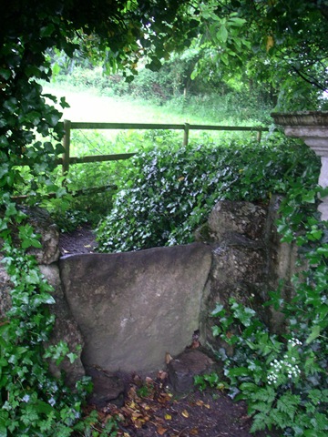
Stiles may be of stone over walls, usually firm and reliable even for the excess weight of a pack,


or wooden and with steps of wildly varying quality, and occasionally two steps over a fence of a height calculated to induce vertigo in my good friend Geoff. These, with a full pack by the end of the day, induce a feeling of venturing into the death zone on Everest.

  PICT0004 (Medium)   talstile(Medium)   PICT0007 (Medium)

 french stile (Medium)


PICT0005 (Medium)

The best however was passed late one morning and is undoubtedly how all stiles should be styled!!!!!!!!!!!!


PICT0008 (Medium)

An improvement in manufacturing was seen in Normandy where the cross piece of many styles was fixed with galvanised roofing bolts instead of the usual pair of rusty nails in England.


A further addition to this post observed near Laval in northern France is a remarkable field gate. This looks as if made by some one with no preconceptions about what a gate should be, and, as Betsy pointed out could be 3,000 years old each part being replaced over the years, with the possible exception of the rock. It has an enormous advantage in design over conventional farm gates, the uprights of which, within a short time, lean inwards due to the weight of the gate, making it difficult to open. This counter balance design puts no strain on the posts and is easily lifted slightly to open. A second one, inferior, without a rock has also been spotted.

gate1(Medium)                            Gate2(Medium)

To Le Grand Presigny

17.06.08 Tuesday

Descartes (La Haye) to Le Grand Presigny.

We are now leaving Descartes, but a quick further word about this town, it was originally La Haye and claims to have been an important point on the route to Compostella ?from Paris, it has a very old church and remains of a pilgrim hostel. After the birth of its famous son it has gradually changed its name to Descartes, (50 years ago being La Haye-Descates).This seems to be a bit of a metaphor for the change in outlook from religious to secular agnostic that has occurred in europe over the same time period.
We are heading generally southeast towards Limoges up the valleys of three rivers, the Vienne to the west, the Creuse in the middle and the Claise, the most easterly and smallest, that joins the Creuse at Descartes. The ridges between these are only a couple of hundred feet above river level and the route hops over them happily in very largely arable farmland with at one point both cornflowers and poppies growing in the corn, agriculture less intense round here.
A short day as la Roche Posay is a bit far at 25 miles. About 10 miles done today, mostly off road forest and farm tracks. We are on a section of electronic map without detailed GR tracks marked, so followed some very good waymarks until they seemed to be going the wrong way, so backtracked and were about to try another forest track when strongly advised against by an elderly French couple sitting in a car in the middle of nowhere, ?owners of the forest, who knows? So continue following waymarks. Eventally end up here (Le Grand Presigny) on the Claise, which has a good campsite and an impressive (closed) chateau museum and is just as good in terms of southern progress and where we go next. Settled into campsite, looked nearly closed as usual, and noticed a swarm of bees settling into a near by tree. Once settled, us and bees, took a photo and set out to tell some one. Found the gendarmerie they seem moderately interested and maybe have contacted someone who will come and collect them.

Link to where we are on Google Maps

To Descartes

16.06.08

Marcilly sur Vienne to Descartes.

An Epic day, not only did we cross the A10 the Paris to Bordeaux peage (toll motorway), a modern watershed but we reached the town of Descartes. This little town is not only the birthplace of Renato Descartes, philosopher, but also one of the many points of resistance between occupied and Vichy-France during the second world war. The bridge dating from at least the 14th century, was destroyed to prevent German advance and only finally rebuilt in 1959. A temporary bridge was available for the years after the war.
On the way, we passed through Les Ormes which must once have been an important town (the RN10 and the railway still pass through), but obviously the A10 and time have helped to bypass it. There were interesting buildings (eg the rehorseing stables for the mail coaches) but even these are only open for a few days per year.
The tourist office lady was very helpful and confirmed the existence (as far as anything could be said to exist in this town) of our next two campsites.
The walking during the day was good, mostly off road and around 15 miles covered in good time. The weather however deteriorated steadily but imperceptibly during the day, until on arrival in town waterproofs were needed. It has not rained heavily, just persistently, since about 12:00hrs. The minor difficulty in finding the campsite, explained first by questioning its existence, previous campsite experience and the existential environment being enough of a reason for this, was overcome with the help of ladies from the local charity shop, the only place open on a wet Monday in Descartes, who insisted on showing us personally to the site.
Well not quite, we found a café/bar in the main square serving biere and with nice waterproof awnings just opposite the statue of the famous son, the photo may or may not prove its existence. Tim has not got as far as Descartes in his reading yet so is unable to say.

Link to where we are on Google Maps

To Marcilly sur Vienne

15.06.08 Sunday.

I'Ile de Bouchard to Marcilly sur Vienne.

The ladies left us today after meeting us for lunch, it was a good break and a needed rest. We were still on the site in Chinon and had washed, dried and repaired everything by last night. Our little tents were taken down last night and rucksacks packed with gear and food for 2 -3 days as tomorrow is Monday and as we have found to our cost few of the shops that are available to us in the areas we pass through are open on Monday. Change is coming slowly to rural France, farmhouses are renovated as holiday homes in popular areas, shops close and are for sale in others but still bread is available Sunday mornings (mostly) but not Mondays.
The walking was average today and also it was raining lightly all morning, just at the level to make deciding if the unpleasantness of waterproofs was worthwhile. Only around 13 miles covered but the next stage would have made it 20 miles, a bit too much for comfort of ageing joints we think.
One field passed was a crop of poppies, deliberate not accidental, we would have thought we were in Afganistan except for the weather.
Arrived at the site in Marcilly sur Vienne by 14:00hrs to find that the site, on the banks of the river, opened today on 15th June for its short season! Only just in time, we await the arrival of the campsite person to see if it really opens or if we will just be abandoned to our own devices, there is water at least.

Link to where we are on Google Maps

To l’Ile de Bouchard

14.06.08

Chinon to Ile de Bouchard.

An accompanied walk – Betsy became a pilgrim for a day (yes, you too can become a pilgrim for a day). A very straight forward walk 13 miles long, first up into Chinon and then along through wooded tracks. We left the GR3 outside Chinon and joined the GR48 that should take us down to Limoges. We were also joined by a dog, a boxer who tagged along for several miles through the forest and then wandered across the road whenever cars came along, resulting in several people telling us to get it under control. Pas mon chien! Eventually in Isle de Bouchard it went off up one street and we went off rapidly down another. We met up with Jane for lunch by the banks of the Vienne and then returned by car to the campsite in Chinon. The ladies depart tomorrow and we shall continue our journey south. Shopping in town we bought sausages of various kinds from a boucher in Rue Jean Jacques Rousseau which were among the best we’ve ever had, also the bakery just opposite supplied an excellent loaf with Italian style dough and lardons. We had a very good evening meal with local asparagus and green beans.

Short stay pilgrims beware – Tim & Tony have been walking for weeks now and can move very fast, especially when they have found a way to avoid carrying their heavy rucksacks! Still, there was time to enjoy looking at fields of poppies, donkey family with foal, a hoopoe….maybe I could become a pilgrim after all with practice.

Link to where we are on Google Maps

Rest day in Chinon

13.06.08

Friday Rest day in Chinon.

We did meet up with our ladies they had “white knuckled “ down the autoroutes from St Malo and arrived around 20:00 hrs, we then had a good meal out with the main course for 3 of us served in jamjars! The tents they brought with them seem enormous even with two in each one.
Today we are late up, 08:00 hrs, wander round town and do a bit of shopping and try to get the lady in the tourist info to part with a list of camp sites along the GR48 which is our route south now. Unfortunately our route runs along the department boundary between Indre et Loire and Vienne, and we are not in the right one at present so “mais non” was the reply. We will have to try again further down the line as the sites marked on the maps may not be up to date and the Guide Michelin consulted in England before leaving is far from comprehensive.
In the afternoon we went round the chateau (well that’s what you do when in the Loire Valley), and the town although small is of enormous historical importance! Henry the II of England died here and the Hundred Years War was fought over and around this area including the meeting of Joan of Arc with the putative French king (they were losing at the time). A bit of good news and bad – the chateau is being renovated and a lot of serious stone work being done so the visit is not currently as one would like, the good news is it's only 3 euros for some great views up and down the Vienne river.

Link to where we are on Google Maps

To Chinon

12.06.08

Thursday Montsoreau to Chinon

Started early to Boulongerie outside campsite open at 07:00hrs and, after breakfast of a very crisp baguette and ham, headed off up and down the escarpment past more troglodyte houses and up on to top, with a good view of the confluence of the Loire and the Vienne. The GR3 then visits a very old abbey at Fontevruade l’Abbaye about 3 miles south, this involved us missing a turn and trying to get back to the route via a wood with bramble undergrowth and little path. We eventually disentangled ourselves, thank you GPS, and reached this nice little town dominated by a huge abbey with parties of school children about to go round and a Biochemistry conference. We had a coffee and left to follow the GR3 back to the Vienne around the end of a large wooded Military Zone from which strange rumblings were coming. We stopped for a sit down and a bar to eat, and then spotted a TANK in a clearing behind us, we thought better of trying to photograph it and it soon rumbled off,
Three miles across fields took us back to the steep descent to the flood plain of the Vienne and a fairly pleasant 6 miles up the bank to Chinon.
Throughout the day we have had occasional views of the nuclear power station near Chinon. This was one of the first commercial reactors opened by the French in 1957. I don’t know if it is still so, but in France it used to be that if you could see a nuclear power station then you got all your electricity for free. If that rule was applied in the UK then I suspect that the approval process for new reactors would be shortened considerably!
The day has steadily clouded over and we now await the rain stopping before going into town to find a restaurant to eat in with the ladies who have now left Guernsey on the route altered ferry and should be with us for nine this evening.

Link to where we are on Google Maps