Doing it in Style !

PICT0003 (Medium)

This may seem a curious post but I can assure you that considerations of style assume huge importance when carrying a 18kg pack; not only stiles and the chances of getting over them, because of their design or their decrepitude, without ending up in a bed of nettles (always closely associated and often over growing),


PICT0006 (Medium)

   but also kissing gates the precise size of which seldom seems large enough to   accommodate both walker and pack. This produces some bizarre contortions,  inching up backwards on the surrounding fence until the pack rests on top and the gate can pass freely in front of one’s knees being a favourite. It is strange that even on long distance footpaths where walkers might be expected to be carrying ridiculously sized rucksacks there is often just not enough room to get through resulting in a situation not unlike being in a no frills airline seat in front of a bulkhead when the person in the seat in front lies back for a snooze, just NOT enough room.


PICT0002 (Medium)

A fine example of recycling was spotted in Dorset, with a stile from an old tractor tyre and a used telegraph pole.


PICT0011

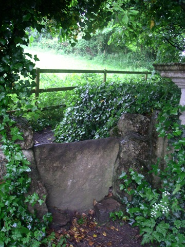
Stiles may be of stone over walls, usually firm and reliable even for the excess weight of a pack,


or wooden and with steps of wildly varying quality, and occasionally two steps over a fence of a height calculated to induce vertigo in my good friend Geoff. These, with a full pack by the end of the day, induce a feeling of venturing into the death zone on Everest.

  PICT0004 (Medium)   talstile(Medium)   PICT0007 (Medium)

 french stile (Medium)


PICT0005 (Medium)

The best however was passed late one morning and is undoubtedly how all stiles should be styled!!!!!!!!!!!!


PICT0008 (Medium)

An improvement in manufacturing was seen in Normandy where the cross piece of many styles was fixed with galvanised roofing bolts instead of the usual pair of rusty nails in England.


A further addition to this post observed near Laval in northern France is a remarkable field gate. This looks as if made by some one with no preconceptions about what a gate should be, and, as Betsy pointed out could be 3,000 years old each part being replaced over the years, with the possible exception of the rock. It has an enormous advantage in design over conventional farm gates, the uprights of which, within a short time, lean inwards due to the weight of the gate, making it difficult to open. This counter balance design puts no strain on the posts and is easily lifted slightly to open. A second one, inferior, without a rock has also been spotted.

gate1(Medium)                            Gate2(Medium)

To Le Grand Presigny

17.06.08 Tuesday

Descartes (La Haye) to Le Grand Presigny.

We are now leaving Descartes, but a quick further word about this town, it was originally La Haye and claims to have been an important point on the route to Compostella ?from Paris, it has a very old church and remains of a pilgrim hostel. After the birth of its famous son it has gradually changed its name to Descartes, (50 years ago being La Haye-Descates).This seems to be a bit of a metaphor for the change in outlook from religious to secular agnostic that has occurred in europe over the same time period.
We are heading generally southeast towards Limoges up the valleys of three rivers, the Vienne to the west, the Creuse in the middle and the Claise, the most easterly and smallest, that joins the Creuse at Descartes. The ridges between these are only a couple of hundred feet above river level and the route hops over them happily in very largely arable farmland with at one point both cornflowers and poppies growing in the corn, agriculture less intense round here.
A short day as la Roche Posay is a bit far at 25 miles. About 10 miles done today, mostly off road forest and farm tracks. We are on a section of electronic map without detailed GR tracks marked, so followed some very good waymarks until they seemed to be going the wrong way, so backtracked and were about to try another forest track when strongly advised against by an elderly French couple sitting in a car in the middle of nowhere, ?owners of the forest, who knows? So continue following waymarks. Eventally end up here (Le Grand Presigny) on the Claise, which has a good campsite and an impressive (closed) chateau museum and is just as good in terms of southern progress and where we go next. Settled into campsite, looked nearly closed as usual, and noticed a swarm of bees settling into a near by tree. Once settled, us and bees, took a photo and set out to tell some one. Found the gendarmerie they seem moderately interested and maybe have contacted someone who will come and collect them.

Link to where we are on Google Maps

To Descartes

16.06.08

Marcilly sur Vienne to Descartes.

An Epic day, not only did we cross the A10 the Paris to Bordeaux peage (toll motorway), a modern watershed but we reached the town of Descartes. This little town is not only the birthplace of Renato Descartes, philosopher, but also one of the many points of resistance between occupied and Vichy-France during the second world war. The bridge dating from at least the 14th century, was destroyed to prevent German advance and only finally rebuilt in 1959. A temporary bridge was available for the years after the war.
On the way, we passed through Les Ormes which must once have been an important town (the RN10 and the railway still pass through), but obviously the A10 and time have helped to bypass it. There were interesting buildings (eg the rehorseing stables for the mail coaches) but even these are only open for a few days per year.
The tourist office lady was very helpful and confirmed the existence (as far as anything could be said to exist in this town) of our next two campsites.
The walking during the day was good, mostly off road and around 15 miles covered in good time. The weather however deteriorated steadily but imperceptibly during the day, until on arrival in town waterproofs were needed. It has not rained heavily, just persistently, since about 12:00hrs. The minor difficulty in finding the campsite, explained first by questioning its existence, previous campsite experience and the existential environment being enough of a reason for this, was overcome with the help of ladies from the local charity shop, the only place open on a wet Monday in Descartes, who insisted on showing us personally to the site.
Well not quite, we found a café/bar in the main square serving biere and with nice waterproof awnings just opposite the statue of the famous son, the photo may or may not prove its existence. Tim has not got as far as Descartes in his reading yet so is unable to say.

Link to where we are on Google Maps

To Marcilly sur Vienne

15.06.08 Sunday.

I'Ile de Bouchard to Marcilly sur Vienne.

The ladies left us today after meeting us for lunch, it was a good break and a needed rest. We were still on the site in Chinon and had washed, dried and repaired everything by last night. Our little tents were taken down last night and rucksacks packed with gear and food for 2 -3 days as tomorrow is Monday and as we have found to our cost few of the shops that are available to us in the areas we pass through are open on Monday. Change is coming slowly to rural France, farmhouses are renovated as holiday homes in popular areas, shops close and are for sale in others but still bread is available Sunday mornings (mostly) but not Mondays.
The walking was average today and also it was raining lightly all morning, just at the level to make deciding if the unpleasantness of waterproofs was worthwhile. Only around 13 miles covered but the next stage would have made it 20 miles, a bit too much for comfort of ageing joints we think.
One field passed was a crop of poppies, deliberate not accidental, we would have thought we were in Afganistan except for the weather.
Arrived at the site in Marcilly sur Vienne by 14:00hrs to find that the site, on the banks of the river, opened today on 15th June for its short season! Only just in time, we await the arrival of the campsite person to see if it really opens or if we will just be abandoned to our own devices, there is water at least.

Link to where we are on Google Maps

To l’Ile de Bouchard

14.06.08

Chinon to Ile de Bouchard.

An accompanied walk – Betsy became a pilgrim for a day (yes, you too can become a pilgrim for a day). A very straight forward walk 13 miles long, first up into Chinon and then along through wooded tracks. We left the GR3 outside Chinon and joined the GR48 that should take us down to Limoges. We were also joined by a dog, a boxer who tagged along for several miles through the forest and then wandered across the road whenever cars came along, resulting in several people telling us to get it under control. Pas mon chien! Eventually in Isle de Bouchard it went off up one street and we went off rapidly down another. We met up with Jane for lunch by the banks of the Vienne and then returned by car to the campsite in Chinon. The ladies depart tomorrow and we shall continue our journey south. Shopping in town we bought sausages of various kinds from a boucher in Rue Jean Jacques Rousseau which were among the best we’ve ever had, also the bakery just opposite supplied an excellent loaf with Italian style dough and lardons. We had a very good evening meal with local asparagus and green beans.

Short stay pilgrims beware – Tim & Tony have been walking for weeks now and can move very fast, especially when they have found a way to avoid carrying their heavy rucksacks! Still, there was time to enjoy looking at fields of poppies, donkey family with foal, a hoopoe….maybe I could become a pilgrim after all with practice.

Link to where we are on Google Maps

Rest day in Chinon

13.06.08

Friday Rest day in Chinon.

We did meet up with our ladies they had “white knuckled “ down the autoroutes from St Malo and arrived around 20:00 hrs, we then had a good meal out with the main course for 3 of us served in jamjars! The tents they brought with them seem enormous even with two in each one.
Today we are late up, 08:00 hrs, wander round town and do a bit of shopping and try to get the lady in the tourist info to part with a list of camp sites along the GR48 which is our route south now. Unfortunately our route runs along the department boundary between Indre et Loire and Vienne, and we are not in the right one at present so “mais non” was the reply. We will have to try again further down the line as the sites marked on the maps may not be up to date and the Guide Michelin consulted in England before leaving is far from comprehensive.
In the afternoon we went round the chateau (well that’s what you do when in the Loire Valley), and the town although small is of enormous historical importance! Henry the II of England died here and the Hundred Years War was fought over and around this area including the meeting of Joan of Arc with the putative French king (they were losing at the time). A bit of good news and bad – the chateau is being renovated and a lot of serious stone work being done so the visit is not currently as one would like, the good news is it's only 3 euros for some great views up and down the Vienne river.

Link to where we are on Google Maps

To Chinon

12.06.08

Thursday Montsoreau to Chinon

Started early to Boulongerie outside campsite open at 07:00hrs and, after breakfast of a very crisp baguette and ham, headed off up and down the escarpment past more troglodyte houses and up on to top, with a good view of the confluence of the Loire and the Vienne. The GR3 then visits a very old abbey at Fontevruade l’Abbaye about 3 miles south, this involved us missing a turn and trying to get back to the route via a wood with bramble undergrowth and little path. We eventually disentangled ourselves, thank you GPS, and reached this nice little town dominated by a huge abbey with parties of school children about to go round and a Biochemistry conference. We had a coffee and left to follow the GR3 back to the Vienne around the end of a large wooded Military Zone from which strange rumblings were coming. We stopped for a sit down and a bar to eat, and then spotted a TANK in a clearing behind us, we thought better of trying to photograph it and it soon rumbled off,
Three miles across fields took us back to the steep descent to the flood plain of the Vienne and a fairly pleasant 6 miles up the bank to Chinon.
Throughout the day we have had occasional views of the nuclear power station near Chinon. This was one of the first commercial reactors opened by the French in 1957. I don’t know if it is still so, but in France it used to be that if you could see a nuclear power station then you got all your electricity for free. If that rule was applied in the UK then I suspect that the approval process for new reactors would be shortened considerably!
The day has steadily clouded over and we now await the rain stopping before going into town to find a restaurant to eat in with the ladies who have now left Guernsey on the route altered ferry and should be with us for nine this evening.

Link to where we are on Google Maps

To Montsoreau

11.06.08

Saumur to Montsoreau GR3

A good day, at last a bit of up and down – the GR3 follows the south bank of the Loire upstream southeast by climbing the 200ft escarpment that looks north behind the chateau. It then dips up and down passing through the first vineyards we have seen in France – the local grape appears to be Cabernet Franc (part of the Bordeaux mixture for all the great wines of that area). But here used to make Rose wines such as the good Cabernet de Saumur we enjoyed last night, this is significantly better than most of the Cabernet D’Anjou that also comes from around here and is all we see at home.
The GR dips up and down the cliffs in which generations of French troglodytes have made their homes. Most of the shallow cave systems that have been excavated are now used as garage space and the rocks that have been scavenged from past collapses used to build homes next to the cliffs. But some are caves growing mushrooms and one we passed has turned into a hotel. Some of the chimneys from these open on to the cliff tops looking very odd when a chimney emerges from the grass on the cliff edge.
The paths used by the GR are obviously very old and it is easy to envisage that we are following paths more than 2 millennia old and maybe used by Roman winemakers.
There is an extensive acreage of vines along the cliff tops extending well south on the calcareous very well drained soil. These have just set fruit, and spraying to prevent mildew and tying back the trailing vines (the latter labour intensive) is well underway.
The steep slopes although short have tested the knee joints of both of us and while no dramatic problems have arisen it is obvious that we shall have to be careful and hope that the terrain continues to provide a gentle stressing of those parts that have become unaccustomed to this type of exercise over the last four weeks.
Tomorrow we should be in Chinon on the Vienne, the north flowing Loire tributary that we will follow south for some time to come. We also have a chance to replace items like socks and restock small amounts of spices and suchlike that it is impractical to buy on the way!

Link to where we are on Google Maps

To Saumur

10.06.08

La Breille Les Pins to Saumur.

Up at 06:30 to a cloudless sky and therefore, an early start at 07:00. We were still later out of the campsite though than most of the inhabitants who were living in the static caravans. They seemed to be of east European extraction and we assumed that they were probably fruit picking for a local farmer.
A quick 3.5 miles through the nearby woods and over a small hill to Brains sur Allones. As Tony put it “brains for breakfast”. At the top of the small hill in the centre of the wood we could see in the distance a large block of flats, (“abot loike yow cud see in Dudeley from Kinva Edj”) this later turned out to be the chateau above the Loire at Saumur. We next saw it at 11:30 as it appeared from behind a farmhouse after a mainly road walk that got steadily hotter until we hit town on the island in the Loire linked by 2 superb bridges 1 to each bank, which is about 1km long and is maybe a third of the town of Saumur. About 13 miles today and a hot afternoon lying on campsite and shopping for dinner in town. Saumur is probably the size of Worcester and is the largest town we have been in since Laval (which was wet and horrid).
We shall now process gently up the Loire valley over two days to Chinon, a slightly smaller town, where with the aid of the miracle of modern telecommunications (well it is a latter day pilgrimage), we may meet up with the two most important people in our lives on Thursday evening.

Link to where we are on Google Maps

To Les Loges

09.06.08

Noyant to La Breille les Pins (well not really)

A good long day of three surprises. We are now passing through an area of very well drained sandy soils much more in use for arable farming than the rich cow lands north of here. In spite of this, these three ladies caught my eye early in the morning. The sun however was not rising and the day remained cool until midday when the sun banished the cloud giving us temperatures up to 30degC. Also early in the morning the first surprise a barn owl looking for a roost after a hard days night.
The second surprise was a metre long Grass snake snoozing in the sun about 13:00hours. He was very surprised in the grass in the middle of the track when we thundered up one in each tractor rut, and did not know which way to go, finally shooting across my rut 2 ft in front of me. I DO NOT LIKE SNAKES. Even harmless ones.

Mid morning we arrived at Parcay-les-Pins hoping to find a midmorning cup of coffee. But the village bar was closed all day Monday (but they do claim to speak very good English!). We availed ourselves of the bar’s seats in the square whereupon a local asked us whether we needed a drink of water; how kind but we still have plenty in our water bottles. A quick visit to the local shop got a couple of cans of fizz to drink and also showed that the most popular newspaper being sold there was the Daily Telegraph. More signs suppose of French villages being taken over by Brits. How awful.

We pressed on in the heat after lunch, expecting to arrive at La Breille les Pins campsite about 15:00. I will not dwell on the minor navigational error that made us about 30mins late, very hot and glad to have got there. Then the third surprise of the day, the campsite we had got off local leaflets in yesterday's campsite was not where we thought it was but 2 miles away by road. With hot feet we pressed on after directions and a beer from people in what we think was a closed local club, we probably got club rates at 1.6 euros each, I think they took pity on us.
Day still hot and washing drying well in the breeze as this blog is prepared in the most comfortable place yet – a settee in the games room on the site on a fair sized lake.

Link to where we are on Google Maps

To Noyant

08.06.08

Sunday Le Lude to Noyant

Not our day of rest – about 16 miles including a bit of difficulty finding the GR36 (our new route down to Saumur where we pick up the GR3 up the Loire). We then did a mix of road, field, wood and marsh, the latter only a short section and easily, with our hard won expertise, circumnavigated.
On the one occasion we lost the route we passed through the small village of Disse sous le Lude where a motor bike cum tractor convention/car boot sale was in progress, we thought about buying a vintage tractor but could not see how to get it home, but it would have been really useful!!
We scored points for another hare and a small deer and the day passed in the usual fashion, arriving in Noyant at about 15:00hrs. This is just about the smallest Municipal we have been on with 12 pitches only and absolutely nothing open in the village, not even a single bar, on a Sunday afternoon. We had planned ahead yesterday for this eventuality, so we are carrying 2 days food (for today and tomorrow) as getting food in little villages in France can be notoriously difficult on Mondays.

Link to where we are on Google Maps

Rivers!

Notes on the geography of the last few weeks.

We had not realised quite how flat this area of northern France is. In the north of Normandy around Cherbourg the land is about 300ft above sea level and obviously as we followed the coast down to Le Mont St Michel we never rose above 100 ft and often were walking along the shore line which was crossed by multiple small rivers/ streams each with their own mini estuary culminating in the walk across the sands of Le Mont St Michel with it’s three main water courses entering the sea there. The most southerly of these was Le Couesnon flowing north from the high (300ft) lands south of Fougeres.
Travelling southeast to Laval we met the Mayenne at Laval at a height of somewhat less than 200ft having “peaked” at about 600ft around Ernee as we crossed the watershed from those northern flowing steams to those draining southwards into the mighty Loire including the Mayenne joining it at Angers and the Sarthe flowing from Le Mans at the dizzy height of 150ft down to the Loire also at Angers at 49ft above sea level. This drop of only 100ft over 52miles as the crow flies and with the surrounding country not rising above 150ft with few exceptions, goes quite a long way to explaining our problems with land drainage during the last 10days and the size of these sluggishly flowing rivers. Most of which with the weirs and locks on then are navigable to boats a lot bigger than British Narrow boats.
We are currently at Le Lude on the Loir (110ft above sea level) a tributary of the Sarthe and the chateau here is poised a dizzying 30ft above the river on “high” ground.
I hope that the next few days will see no more of the sort of ground we have been covering and the soils seem sandier and better drained than further north. But we shall not get above 500ft for several weeks until south of Poitiers, and over 1000ft until south of Limoges, as we reach the watershed between those rivers draning northwards into the Loire and those southwards into the Dordogne which loops south then west to enter the sea with the Garonne in the Bordeaux estuary.

Rest Day

07.06.08

Day off in Le Lude.

Morning well spent talking to tourist information lady, getting campsite info and washing. Afternoon visiting the local chateau in town which was more interesting than most being still lived in and with a guide who made the effort to speak both French and English. Medieval stronghold pre 100 years war, captured and held for a few year by the English, protected better than many during La Revolution with many treasures rediscovered during a major reconstruction in the 19th century and more or less in the same family since (haven’t the French heard of inheritance tax?). Very well preserved and although the pictures of the past family members got a bit much there was a very nice old Flemish oil painting. Though the highlight were the old kitchens with wood burning ovens and copperware with vaulted ceilings still used to make the preserves on sale at the gate.
We had our first barbecue ce soir which explains the lateness of this blog . On the banks of the Loir with some dry wood and the grill Tony has been carrying, we had to use it or it would be going home next week.

Link to where we are on Google Maps

To le Lude

06.06.08

Bazouges sur Loir to Le Lude.

Both these towns are on the Loir, a tributary via the Sarthe of the Loire (which is the one you’ve all heard of). Both are very pleasant with a river big enough to boat on may be the size of the Wye at Hay, but since we are still in the flatlands they are slow flowing and with weirs to control and increase volume of water retained.
They are however 18 miles on foot apart. It was a good day with about half of the walking on roads and half on forest tracks (without significant mud or water). Le Lude is a bit bigger and has allowed us to solve two impending problems , a bank with a guichet (or ATM), and a 24 hour petrol station which allowed us 650mls of unleaded at 1.20 Euros without asking awkward questions in a language we are ill prepared to answer in. Thus we now have money and stove fuel.
On the way here we saw a hare, it started up from a ditch by a house we passed and ran 50yds down the road. We suffered the addition of about 3/4mile to our route to go round what we believe to be a hunting enclosure for boar.
The camping here is by the river and we will stay here for tomorrow to gather a bit of data about the next leg to Saumur about which we have little idea of where to stay apart from one site in a not ideal position. We need to talk to the nice lady in the tourist info who was just shutting up shop as we arrived and was already late.
Photo of the Chateau at Le Lude which is quite startling in the middle of a small town.

Link to where we are on Google Maps

To Bazouges sur le Loir

05.06.08

Thursday Precigne to Bazouges sur le Loir

A good afternoon drying and we walked out in good order today, it was not to last. The route joined the GR and passed through the usual pleasant green lanes, some of which had been mown presumably by the local communities, the lanes gradually became boggy and then disappeared under water, we did our usual trick of getting through the hedge to find a nearly dry green lane paralleled ours. Great we thought, but after a few hundred yards the green lane entered a meadow with planted trees and there was now a wide full ditch between us and our original path. It rapidly became apparent that this was a water meadow and loud cursing could be heard as the water level topped the boots. At this point with one of your gallant heroes up to mid calf with full boots and the other removing boots and socks for sandals finding dry land was a priority. This appeared as a metalled road on the other side of a 4 foot ditch crossed on a bridge of sighs, creaks and snappings of some well seasoned old branches. As we gathered our wits and assessed the situation it became apparent that apart from one of us undoing the good of the previous afternoon re prevention of trench foot, we were unscathed. But were rapidly being treated as donors by the local mosquito population, still even if France is no longer rabies free it does not have malaria.
We had lunch in the pleasant town of Durtal and then through wooded hills (well what passes for hills round here, 300 feet above sea level) and down to the town of Bazouges with some nice old buildings on the opposite bank to the campsite.
We then shopped in the corner shop run by a pleasant Moroccan Frenchman and even managed a conversation about Moroccan cooking!!. It may be that since French was not his native tongue either he was more willing to try hard to be understood. Confit de citron preserved lemons.

Link to where we are on Google Maps

To Presigne

04.06.08

Sable sur Sarthe to Precigne.

A rest day! Well only 6 miles, late start tents almost dry, finish for lunch and washing with a good chance of drying . Another interesting stile – see the blog still to come (too many photos to upload from here). We first walked into town to cross the river and picked up the GR 365 on the opposite bank, after ¾ hour we were 100 yards from our camp last night, another dog leg in the route results in us being only 4 miles away from yesterday but 6-7miles walked. The walk down the bank was much better than on the roads and startled this frog ? species with a bright green stripe from nose to tail.
Now at our ease in the Municipal at Precigne watching washing dry (hurray) , a necessary duty as clouds still threaten, but currently in warm sunshine.
When clothing suitably dried, then time to stroll into town to find a cool beer and other liquids to go with tonight’s tea.
Feet feeling relaxed today after just a few miles and not too much road walking.

Link to where we are on Google Maps

To Sable sur Sarthe

03.06.08

St Denis to Sable sur Sarthe

We knew these two days would not be fun, we had 30 miles by direct road to link up the 2 GR systems. This second day was well started by the previous afternoon in St Denis with sun and breeze so we started drier than for some days. It was still trying to rain but very slowly cleared during the day. The meteo Tim saw on the papier of the monsieur in charge of the café/bar we had coffee in yesterday agreed with Geoff’s text that we may be due a few days good weather, I hope so, this may mean we can smell less like the pilgrims of old. We arrived in Sable at about 1400 and pitched tents to dry them out 17-18 miles today and then walked into town. The site has red squirrels, seen as we arrived and the weather has looked up since, now sitting in the evening sun drying out after a meal that only had to be carried 1 km from town. ( So for Ali, plenty veg melon and nectarines and tomatos, as well as the standard bottle of wine, missing for the last 2 days ). Next few days are not problems of carrying food or shopping and so we look to be in or around Saumur for the arrival of our two gracious ladies. (The first supply visit).
Really no interesting pics to show views or whatever so some sculpture from Sable from our shopping expedition and a view of the Harris Butchers bag that has been with him since Tim started (thanks Mark).

Link to where we are on Google Maps

To St Denis du Maine

02.06.08

Laval to St Denis du Maine

Set off in the rain after a wet night. Walking down the main road for the first hour in the rush hour in the rain with articulated lorries only inches away was no fun but it made the rest of the day during which rain was intermittent on the side roads seem quite pleasant by comparison. Much of the day looked like the photo.
We arrived at St Denis at about 13:30 having covered 15 miles and starting at 07:30, well we certainly didn’t want to stop. Found the campsite very nice on the shore of a small lake, but it is Monday so no shops or bakeries open. Still we have food for tonight and a Mars bar got us here. I think both our BMIs are dropping.
However the afternoon provided some precious drying time a breeze and the sun came together, even though clouds threatened and close observation was needed to prevent steps backwards in the drying process. Someone’s socks have been wet for days!!!
A little amble up into the village to see a) the local hotel closed and up for sale (anyone fancy a little lifestyle change?) b) the historic church stuffed full of statues, limestone frieze, carvings and C14 wallpaintings (so much to see in 1 place with an English soundtrack) and c) the ancient village washhouse which seemed to be a large wooden platform that could be lowered into the river.

Link to where we are on Google Maps

To Laval

01.06.08

Sunday Port Brillet to Laval or St Pierre le Potier just south.

Comfortable night spent out of the rain in the Auberge, started walking at 08:00 after le petit dejuener. Got a different baguette from the boulangerie opposite, with seeds (Les Grivels I think) very good for lunch.
Tony got fairly stressed when his HTC Kaiser (phone, pda, gps, camera et al) refused to boot up at the start of the route, but after much bad language, and a phone call home to discover how to do a hard reset on the device (how can you press all those buttons with only 1 pair of hands), he finally got the machine going again and all the software reloaded. It’s amazing what you can do when you are walking along.
Uneventful walking along green lanes paralleling the main line into Laval, until I was startled (Tim) by the TGV to Laval that crept up behind me, I thought I was being run over.
At one point the pathway did a detour of ½ mile or so to get over the A81 autoroute. Why? The path was there first! Why wasn’t there a suitable bridge over the motorway similar to the superb bridge that takes the Pennine Way over the M62 in Yorkshire?
We walked through Laval and down the River Mayenne which is navigable with quite large locks and weirs and a superb chateau close to the river.
Our first choice campsite had closed – taken over by a Macdonalds and a van sales yard – such is progress. We also chose to sit in a bus shelter like 2 vagrants for 15 minutes or so when the rain got particularly heavy while waiting for the rain to ease. Why does the 2 km you don’t feel you should have to do feel the worst?

Link to where we are on Google Maps